
The Great Granite Dam Failure
When emergency weather warnings blare through your phone or TV, cautioning “Turn Around, Don’t Drown,” they are serving as a reminder of the very real dangers posed by flash floods in Central Texas. The Colorado River has become a focal point of Austin’s active lifestyle crowd with idyllic images of kayaking gliding along the shimmering waters. However, over a century ago, this very river unleashed chaos and devastation upon the in a catastrophic flood that forever changed the city’s landscape.
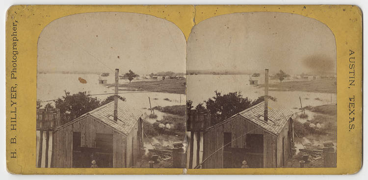
In July 1869, the water levels rose to a staggering 51 feet above sea level, causing the river to overflow and inundate not only Austin but also nearby areas such as Bastrop and La Grange.
In a desperate bid for survival, Austinites were compelled to seek refuge on rooftops to escape the relentless deluge.
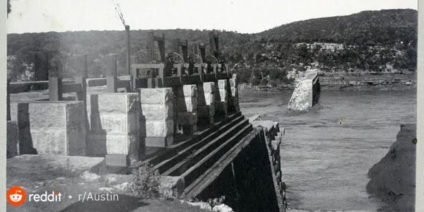
The extent of the destruction forced city officials to reevaluate the infrastructure, particularly the railroads, to ensure that future generations would not endure the same level of devastation in the event of another deluge.
According to accounts from the “Annals of Travis County” by Frank Brown, the flood of July 1869 was the highest and most disastrous in over a hundred years. It surpassed the recollections of even the oldest inhabitants and dwarfed previous floods in volume by a significant margin.

https://texashistory.unt.edu/ark:/67531/metapth125197/m1/1/
The relentless downpour began in the first week of July, with intermittent rains persisting for several days. The river gradually began to rise, initially without causing significant alarm. However, on the 6th, a colossal flood surged forth in massive waves, submerging low-lying areas and spreading across valleys up to the hills. The river swelled, reaching the bluffs. Initially, it seemed that the peak had been reached, but the water continued to rise rapidly, instilling great alarm among the populace. The highest point was ultimately reached on the evening of July 7, around 9 o’clock, with an estimated rise of forty-six feet. The velocity at which the waters surged down from the narrow channel between the mountains to the wider expanse below was terrifying, causing the middle of the river to tower higher than its sides, presenting a truly appalling spectacle.
https://digitalcollections.smu.edu/digital/collection/jtx/id/1236
The impact of the flood was felt far and wide. Thomas McKinney’s mill on Onion Creek was destroyed, Bastrop was submerged, and the planned route of the Houston and Central Texas Railroad was altered to pass through the newly established town of Elgin.
Pedernales River – near Johnson City – 33.0′ July 1869 Onion Creek – Hwy 183 (Austin) – 38.0′ July 3, 1869 (newspaper accounts) Colorado River – at Austin – 51.0′ July 7, 1869 at Bastrop – 60.3′ July 7 or 8, 1869 at Smithville – July 8, 1869 – several feet higher than the 47.4′ Dec 4, 1913 above LaGrange – 56.7′ July 9, 1869 at Columbus – 51.6′ July 1869 (river split above town and made into island) at Wharton – 51.9′ July 12, 1869 near Bay City – 56.1′ July 1869
Today, a flood marker stands near the Buford Tower in downtown Austin as a poignant reminder of the devastating flood. Interestingly, the Austin American-Statesman, the city’s newspaper, was not yet founded when the flood occurred, and it was only in 1924 that the flood marker was installed.